
Geodiversity at the Lewes Downs
By Peter Anderton of the Sussex Geodiversity Partnership
Geodiversity is the variety of rocks, fossils, minerals, soils and landscapes which can be found and observed in any chosen area. It also includes the variety of natural processes, such as stream erosion, which modify our present environment and which modified environments in the geological past. Geodiversity provides the foundation for habitats, ecosystems and biodiversity.
In Sussex, geodiversity is dominated by the Chalk rock which underlies the South Downs and by the older sandstones and clays which underlie the High Weald, the Low Weald and the Wealden Greensand landscapes. The Chalk was deposited between 100 and 66 million years ago during the Upper Cretaceous epoch of geological time.

Here is a Google Earth view of Lewes Downs. This is an excellent area for an introduction to the geodiversity of Chalk. It’s a compact and accessible area, combining exposures of Chalk rock with downland landscape. Preservation of the natural features is enhanced by three natures reserves located on Malling Down, Southerham Farm and Mount Caburn.
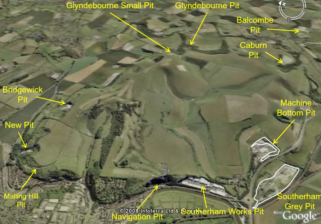
The Chalk rock which makes up Lewes Downs is exposed in eleven former chalk pits. Chalk has been used over the centuries for a variety of agricultural and industrial purposes. For most of that time it was extracted from small pits but the arrival of the industrial revolution led to the excavation of large quarries such as the Southerham Works and Grey Pits. Today all of these pits are disused. Malling Hill, Bridgewick, and Glyndebourne Small pits have public access but the rest need permission to visit. The Chalk cliffs of the Navigation and Southerham Pits are a local landmark and can be viewed from the Railway Land reserve and adjacent footpaths, while Caburn and Balcombe pits can be seen from the top of Mount Caburn.
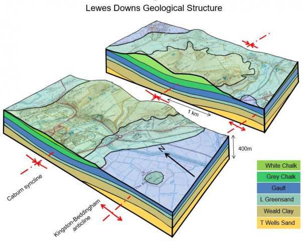
Here is a block diagram of the bedrock geological structure of Lewes Downs. The area is unusual because here the general southerly dip of the Chalk layer of the South Downs is interrupted by local fold structures which result in an offset of the Chalk escarpment. The Chalk is preserved in a downfolded structure, the Caburn syncline, where it forms the Lewes Downs. To the south the Chalk has been eroded over a complementary upfolded structure, the Kingston-Beddingham anticline.
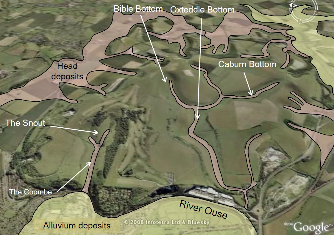
This Google Earth view shows the location of the dry valleys on Lewes Downs and the distribution of superficial deposits. The higher ground is mostly underlain by thin soils on Chalk bedrock but in the dry valley bottoms and on the flanks of the Downs superficial deposits known as Head occur on top of the Chalk.
During the Pleistocene period starting about 500,000 years ago a series of glacial episodes occurred, when ice covered much of Britain north of the Thames. During these cold periods the South Downs experienced a periglacial environment. They were seasonally snow-covered and permanently frozen or frozen for most of the year. However, the topmost layer thawed during the short summers. Alternate freezing and thawing shattered the nearsurface Chalk producing a chalky mud with fragments of more resistant chalk and flint. The melt water in summer saturated the soil and allowed it to flow downslope over the impermeable frozen ground beneath and accumulate in the valley bottoms as Head deposits.
Warmer episodes, particularly at the end of each glacial episode, probably produced increased meltwater and concentrated stream flow while the ground at depth was still frozen and impermeable. The higher streamflow was able to erode and deepen the valleys when the subsurface was frozen.
During the interglacial warm periods and the 10,000 years since the end of the last glaciation to the present time the Chalk valleys became dry because under these conditions the Chalk absorbs most of the rainfall and prevents significant streamflow.
During the glacial periods, the trapping of water in glaciers and ice sheets caused sea level to fall by as much as 140m and the River Ouse cut a deep channel well below current sea level. In the early post-glacial period, melting of the ice caused sea level to rise again and flood this wide deep channel, forming an estuary. In the later postglacial period, this estuary gradually infilled with alluvial sediment across which the present-day Ouse flows in an abnormally wide valley.

Bridgewick Chalk Pit in Malling Down nature reserve. Chalk rock representing the White Chalk (lower Lewes Chalk formation) is exposed at the top of this disused quarry. The middle and lower slopes are covered by weathered debris. Large blocks of chalk lie on the quarry floor, some relatively fresh and white, others weathered and grey.
The quarry floor and lower debris slopes are relatively open and accessible for examining chalk boulders and fragments. Many of the boulders and blocks contain irregular shaped nodular flints and some contain characteristic chalk fossils such as brachiopods, bivalves and echinoids. Inspection of the chalk rock fragments at the foot of the debris slopes often reveals these fossils. They indicate a marine environment at the time the Chalk was deposited, with relatively deep clear waters.
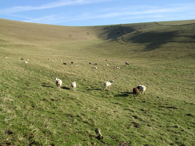
Looking north east up the Bible Bottom dry valley on the Southerham Farm nature reserve. Note the rounded valley bottom profile indicative of the role of cold climate (periglacial) weathering in its formation. The north west facing slopes at the right of the picture receive less sunlight and have developed scalloped hollows with steeper slopes. These may have been sites of persistent snow patches in colder times.
See the Sussex Geodiversity Partnership website here
